
A rain event like this has not been seen since at least 2016 and probably not since the 1990s, a weather forecaster said.
There are concerns the heavy and persistent rain will see serious flooding events and potentially landslides.
“We haven’t seen anything like this since the late 1990’s,” Forecaster Jane Golding told ABC.
“The multi-day rainfall from this event looks like much more than we had in the June 2016 east coast low which was last significant east coast low and potentially we haven’t seen anything like this since the late 1990’s,” she said in a statement.
The forecaster was concerned about flooding and the potential for landslides in mountainous areas and near the coast.
“So the system has the potential to produce significant overland flooding, flash flooding of creeks and land slips along the steep mountains that come down towards the coast,” she said.
“It is just starting to increase, some of the rates we have seen over previous days over other stretches have been in the 100’s of millimetres and there is no reason not to expect more than that over the next coming days.”
Update from Sydney’s Bureau of Meteorology
Severe Weather Update: widespread heavy rain & flood risk along the east coast. Video current 2 pm AEDT 8 February 2020.
— Bureau of Meteorology, Australia (@BOM_au) February 8, 2020
For the latest forecasts & warnings visit https://t.co/Qs1ZcX4YTb; follow advice from emergency services @NSWSES @QldFES #NSWfloods #Qldweather pic.twitter.com/pV1ormV9hS
People were urges to avoid being out on the water as extreme swell, waves and high winds battered the coast.
“Marine Rescue NSW has urged boaters to take extreme care this weekend. Severe Weather Warnings are current for damaging winds, heavy rain, abnormally high tides & damaging surf for most of the coastline,” a statement read.
NSW Fire and Rescue service is warning motorists not to drive through flooded roads.
With heavy rainfall expected over the coming days, please stay safe on the roads.
— Fire and Rescue NSW (@FRNSW) February 7, 2020
If you see flooding, please do not attempt to drive, ride or walk through it. #NSWFloods pic.twitter.com/XL0zELnhA1
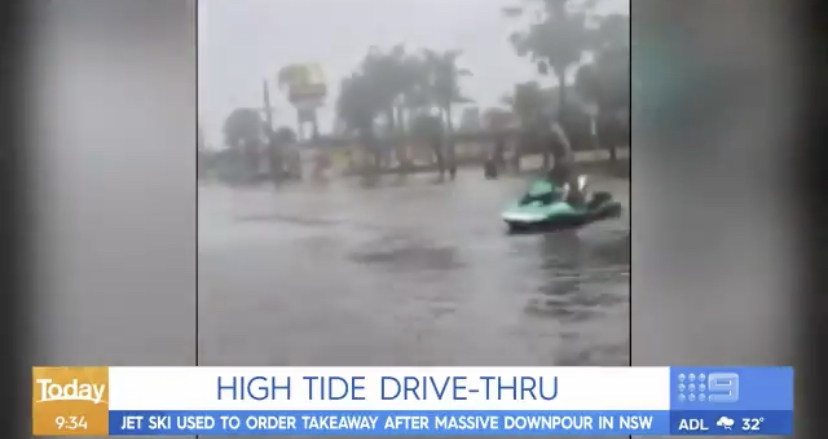
Meanwhile, a man on the Central Coast north of Sydney was seen on social media using his jet ski on a Main Street.
The man is said to have picked up McDonalds using his JetSki as flooded streets made it impossible for cars. However the media reports were exaggerated as the local fast food store was not operational.
Forget the car – a jetski has been used to order McDonalds on the New South Wales central coast – after a downpour turned streets into rivers. #9Today pic.twitter.com/hImYsnp8rb
— 9News Australia (@9NewsAUS) February 7, 2020
Sydney weather : severe weather warning issued for NSW
TOP PRIORITY FOR IMMEDIATE BROADCAST
Severe Weather Warning
for DAMAGING WINDS, HEAVY RAINFALL, ABNORMALLY HIGH TIDES and DAMAGING SURF
For people in Mid North Coast, Metropolitan, Illawarra and parts of Northern Rivers, Hunter, South Coast, Central Tablelands and Southern Tablelands Forecast Districts.
Issued at 10:32 am Saturday, 8 February 2020.
DANGEROUS CONDITIONS: VERY HEAVY RAIN, HIGH WINDS, LARGE WAVES AND TIDES
A trough lying along central and northern parts of the New South Wales coast is bringing persistent rain and windy conditions to many areas. This trough is expected to deepen and gradually extend into the southern coast later today and Sunday.
HEAVY RAIN, which will likely cause FLASH FLOODING and RIVERINE FLOODING, is forecast for parts of the Mid North Coast, Hunter, Sydney Metropolitan, Illawarra and eastern parts of the Central Tablelands (including the Blue Mountains) forecast districts today and Sunday.
There is potential for very heavy (torrential) rainfall and life-threatening flash-flooding in the Central Coast, Sydney Metropolitan, Illawarra and eastern parts of the Central Tablelands (including the Blue Mountains) districts, particularly overnight tonight.
The location of the heaviest rain will be determined by the movement and strength of the coastal trough, and the development of any transient low pressure circulations embedded within it. In addition slow moving thunderstorms will create possible areas of intense rainfall.
DAMAGING WIND GUSTS, in excess of 90 km/h, are possible along the coastal fringe between Ulladulla and Forster later today and Sunday.
ABNORMALLY HIGH TIDES are forecast this morning, and the sea water level may exceed the highest tide of the year.
DAMAGING SURF CONDITIONS, with waves exceeding 5 metres in the surf zone, are forecast to develop tonight or Sunday, and may produce significant beach erosion in areas exposed to the east.
A Flood Watch and a number of Flood Warnings have also been issued for this event.
Locations which may be affected include Byron bay, Coffs Harbour, Port Macquarie, Taree, Newcastle, Gosford, Sydney, Katoomba, Lithgow, Wollongong, Nowra, Ulladulla and Moruya Heads.
Rain Event Totals within the 48hrs to 9am Saturday:
Around 300mm has been recorded at stations surrounding Byron Bay
100 to 200mm has been recorded at stations surrounding the Central Coast (Hunter), with most rainfall falling within the past 24hrs
Around 100mm has been recorded at station surrounding the Sydney Metropolitan.
The State Emergency Service advises that people should:
* Move vehicles under cover or away from trees.
* Secure or put away loose items around your house, yard and balcony.
* Keep at least 8 metres away from fallen power lines or objects that may be energised, such as fences.
* Trees that have been damaged by fire are likely to be more unstable and more likely to fall.
* Report fallen power lines to either Ausgrid (131 388), Endeavour Energy (131 003), Essential Energy (132 080) or Evoenergy (131 093) as shown on your power bill.
* Don’t drive, ride or walk through flood water.
* Keep clear of creeks and storm drains.
* If you are trapped by flash flooding, seek refuge in the highest available place and ring 000 if you need rescue.
* Be aware that run-off from rainfall in fire affected areas may behave differently and be more rapid. It may also contain debris such as ash, soil, trees and rocks.
* After bushfires, heavy rain and the loss of foliage can make the ground soft and heavy, leading to a greater chance of landslides.
* Stay vigilant and monitor conditions. Note that the landscape may have changed following bushfires.
* For emergency help in floods and storms, ring your local SES Unit on 132 500.
The next Severe Weather Warning will be issued by 5:00 pm AEDT Saturday.